
Introduction
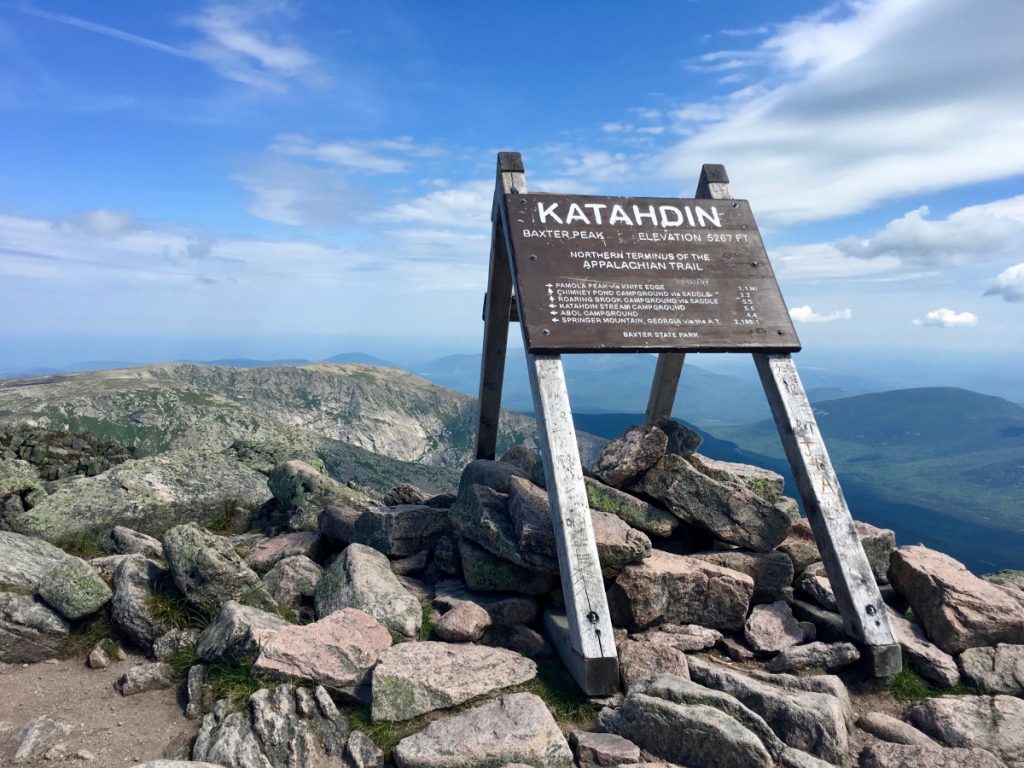
Katahdin Woods and Waters National Monument is a new national park, named after Maine’s tallest mountain (5,268 feet), and designated in 2016 by President Barack Obama, as the Katahdin Woods and Waters National Monument (KWWNM).
Katahdin Woods and Waters National Monument Maine
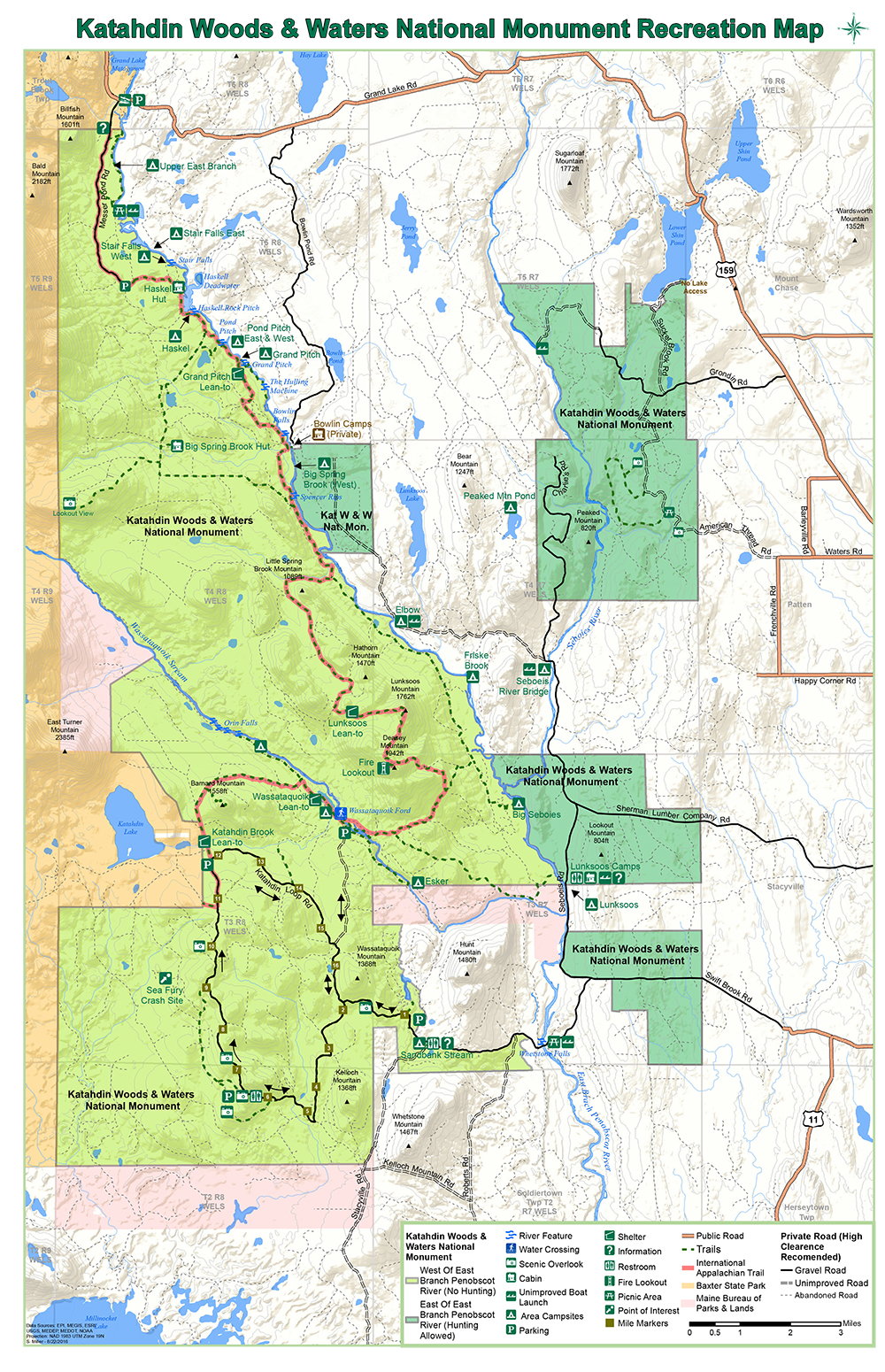
The park spans 87,563 acres (35,435 ha) of mountains and forestland in northern Penobscot County, Maine, including a section of the East Branch Penobscot River.
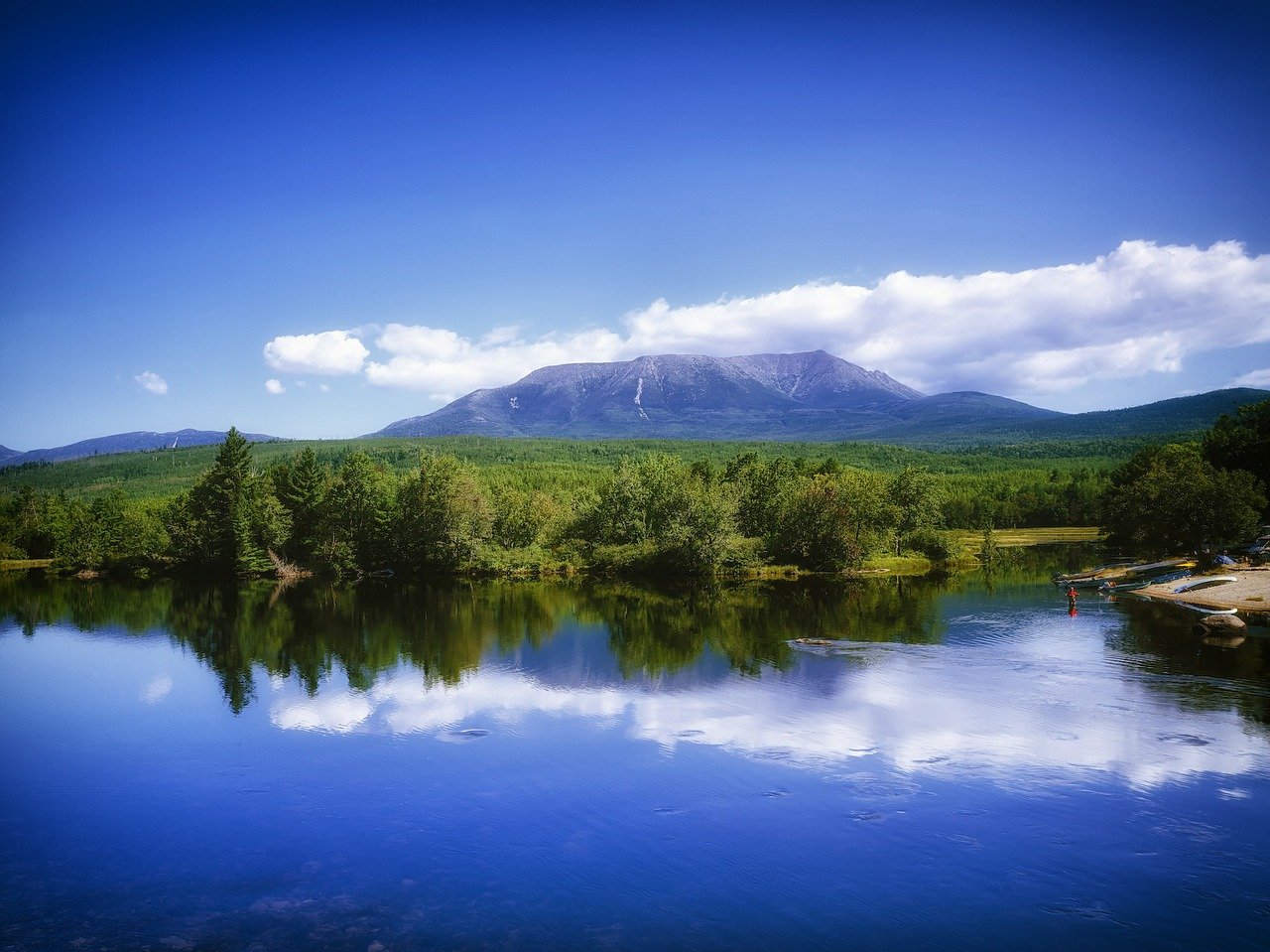
The monument borders Maine's Baxter State Park, offering spectacular views of Mount Katahdin.
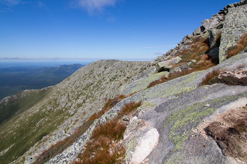
Mount Katahdin Summit
Hiking Katahdin involves an elevation gain of over 4,000’. This is a very strenuous climb no matter which trailhead you chose, with an average round trip time for of 8-12 hours.
Situated at the northern terminus of the Appalachian Trail and the southern terminus of the International Appalachian Trail, Katahdin is a popular hiking and backpacking destination and the centrepiece of Baxter State Park.
Pamola Peak
Paloma Peak is a subsidiary summit on Katahdin at the eastern edge of the Knife Edge ridge, with an elevation of 4919 feet / 1499 meters.
Hiking trails to Pamola Peak include Dudley and Helon Taylor.

Vehicle numbers are capped at the three roadside Katahdin trailheads.
You need to reserve a parking spot at these trailheads.
Be advised that this is a new national monument.
Amenities are limited and signage is sparse.
Cell phone reception can be spotty or non-existent.
Katahdin Woods and Waters National Monument is located in north central Maine approximately a 2.5-hour drive west of Acadia National Park in Bar Harbor and 1.5-hour drive north of Bangor, Maine, both of which are served by regional airports.
Visitors can enjoy canoeing, kayaking, hiking, bird watching, fishing, cross-country skiing, snowshoeing, and snowmobiling on designated trails.
Hunting is allowed on lands east of the East Branch of the Penobscot River.
There are no fees for entrance or camping.
There are no reservations as all sites are first come first served at this time.
There is no public transportation to the monument.
Directions
Known as the Katahdin Woods and Waters Scenic Byway, Route 11 is the main driving route to the park.
The Byway begins at the southern entrance of Baxter State Park and winds its way through Millinocket along Route 11 and the Penobscot River to Patten, ending at Baxter’s northern entrance at Grand Lake Matagamon.
Northern Entrance
To reach the northern portion, take Interstate 95 to Sherman, Exit 264. Turn left (if you’re coming from the south) or right (if you’re coming from the north) off the exit. Continue on Route 11 North to Patten. Take Route 159 from Patten to Mount Chase and then approach on Grand Lake Road to Mattagamon or Haskell Gate, depending upon the season. This approach provides access to the International Appalachian Trail and the upper reaches of the East Branch of the Penobscot, Stair Falls, Haskell Deadwater, Haskell Hut, Haskell Rock Pitch, Grand Pitch, Big Spring Brook Hut, Messer Pond, the Hulling Machine, the Overlook, and more.
Southern Entrance
To access the southern portion, access from Route 11 is via approach from Stacyville on the Swift Brook Road, which crosses Whetstone Bridge spanning the East Branch of the Penobscot River at Whetstone Falls. Beyond the road heads to Sandbank Stream Campsite, Katahdin Loop Road, the Overlook, the International Appalachian Trail, Barnard Mountain, Deasey Mountain, Wassataquoik Ford, Orin Falls, and more. Swift Brook Road also heads toward Hunt Farm, Lunksoos Camps, and parcels on the east side of the East Branch of the Penobscot.
Depending on weather conditions, the 14-mile scenic Katahdin Loop Road may be closed. The loop road provides access to a trail up Barnard Mountain, the International Appalachian Trail, Wassataquoik Stream, and, of course, the Overlook at mile 6.5 with views of Katahdin, Katahdin Lake, and the southern end of Baxter State Park.
Note: The loop road is a winding gravel road with some steep hills and sharp corners.
You can check out current weather conditions here:
Katahdin Woods and Waters National Monument Forecast (weather.gov)
Pet Policy
Dogs are permitted on the trails on leash.
Dogs are not allowed in shelters.
Please note that many of the hiking trails are unsuited for dogs.
Katahdin Woods & Waters Scenic Byway
Katahdin Scenic Byway Maine
The 89-mile Katahdin Woods & Waters Scenic Byway begins at the southern entrance of Baxter State Park and winds its way through Millinocket along Route 11 and the Penobscot River to Patten, ending at Baxter’s northern entrance at Grand Lake Matagamon.
Attractions along the Byway include Shin Falls, Grindstone Falls, Patten Lumberman’s Museum, Baxter State Park & Mount Katahdin, Debsconeag Ice Caves, Ash Hill, Boom House, and the West Branch Penobscot River.

Katahdin Woods and Waters Maine Scenic Byway Map
Operating Hours & Seasons
As of November 23, 2020, the North Entrance Road and Katahdin Loop Road are closed to wheeled traffic for the season. They will reopen in late spring 2021 as conditions permit.
From approximately mid-May to mid-October, two visitor contact stations are operated in the gateway communities of Patten and Millinocket.
The Haskell Hut is open for day use only from May through October.
Overnight use is permitted during the winter season only.
Current status / Covid-19 Update
Based on guidance from the White House, Centers for Disease Control and Prevention (CDC), and state and local public health authorities, Big Spring Brook Hut and Haskell Hut are closed.
Updates will be posted to the park website.
Camping
KWWNM may be brand new, but it is already home to several campsites, huts, and lean-tos. From the comfort and woodstoves of Haskell and Big Spring Brook huts to the open-faced lean-tos at Wassataquoik and Grand Pitch, to the tent sites at Sandbank Stream, visitors will find something to suit their level of comfort with Maine’s wilderness. Be sure to call ahead and speak with the National Park Service regarding reservations and availability.
Accommodation
Please note we have not verified Pet Policy for these listings yet.
Accommodation North Entrance / South Entrance / Places to Eat (nrcm.org)
Winter Activities / Cross Country Ski Trails
The best way to explore Katahdin Woods and Waters National Monument in winter may be by foot or on skis from the North End/Matagamon entrance. This end of the monument is open seven days a week and offers groomed trails for cross-country skiing and snowshoeing.
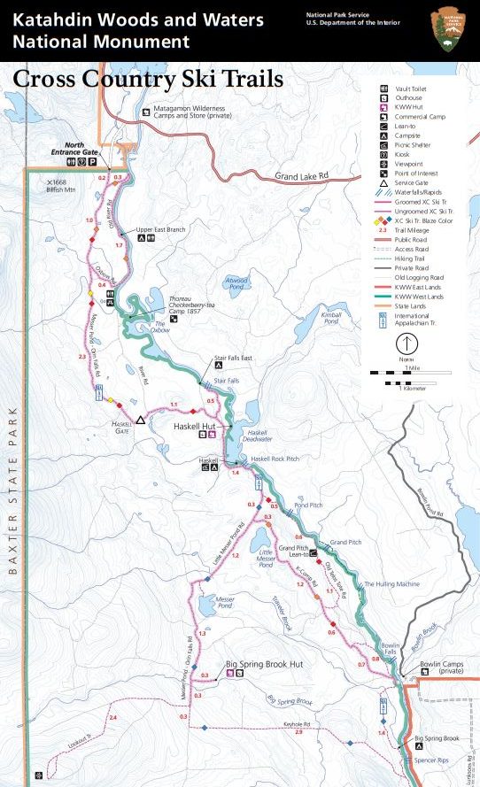
Winter hiking, camping, ice fishing, and fat tire biking are also accessible from the North End.
The North End/Matagamon entrance offers almost 25 miles of packed and groomed trails perfect for snowshoeing and cross-country skiing.
The trails meander along the East Branch of the Penobscot River.
Grooming begins in the North End of the monument in early January.
The trails offer a variety of routes for all ages and abilities.
Trails are groomed for classic and, conditions permitting, skate skiing.
Snowshoers and leashed pets must walk outside of the ski tracks.
Recommended Routes
Old River Road Loop, approximately 3.5 miles
Old River Road to Oxbow Picnic Area, approximately 4 miles
Haskell Rock Pitch, approximately 12 miles
Winter Camping
The following camping options are available in winter:
Walk-in primitive tent sites at Upper East Branch and Haskell Dead Water. Overnight parking permit required.
Walk-in lean-tos at Grand Pitch and Lunksoos Mountain. Overnight parking permit required.
Bunk space in community huts at Haskell Hut and Big Spring Brook Hut. *Reservations and overnight parking permits required.
Hiking Trails Mount Katahdin

Hiking Trails Map - Mount Katahdin Woods & Water Monument Maine
Abol Trail
The Abol Trail is the quickest and shortest from trailhead to summit with a steady, but steep ascent. Few people go back down it, with many opting to return via Hunt Trail instead. The Abol Trail enjoys excellent views. Highlights include Basin Ponds, a marked viewpoint, and Chimney Pond.
3.4 miles (plus 1 mile on Hunt trail 4.4 miles total one way to Baxter Peak).
Elevation gain 3,982ft.
Difficulty level: Very Strenuous.
Trailhead Parking lot: Abol Campground.
Abol Trail Katahdin Woods & Water National Monument Maine
Hunt trail
Similar to the Abol Trail, the Hunt Trail is one of the quickest, least exposed, and more popular trails to the summit of Katahdin.
Outstanding features along the trail include the picturesque Katahdin Stream Falls, the Boulders on Hunt Spur, the traverse of the Tableland, and extensive views in all directions, with 2.4 miles of the trail above tree line.
5.2 miles one-way.
Elevation gain 4,188 ft.
Difficulty level: Very Strenuous.
Trailhead Parking lot: Katahdin Stream Campground.
Helon Taylor Trail
This trail provides a direct route from Roaring Brook trailhead to the Knife Edge trail at Pamola Peak. Hikes should not be attempted in bad weather as this is an extremely exposed trail.
3.2 miles one-way.
Elevation gain to Pamola Peak 3,413 ft.
Difficulty level: Very Strenuous.
Trailhead Parking lot: Roaring Brook Campground.
Dudley Trail
This trail leaves from Chimney Pond campground. It is a short, very steep climb to reach Pamola Peak. This trail is almost entirely above tree line. No water available on this trail.
1.3 miles one-way.
Elevation gain to Pamola Peak 1,988 ft.
Difficulty level: Very Strenuous.
Trailhead Parking lot: Roaring Brook Campground.
Cathedral Trail
The Cathedral Trail is the shortest climb from Chimney Pond to Baxter Peak. It is very steep climbing over three large rock buttresses. The climbing is almost all above tree line. There is no water on this trail.
1.5 miles one-way (1.7 miles to Baxter Peak).
Elevation gain to Baxter Peak 2,353 ft.
Difficulty level: Very Strenuous.
Trailhead Parking Lot: Roaring Brook Campground.
Saddle Trail
The Saddle Trail is the easiest for beginners due to its gradual ascent. The most difficult section is the 0.2 mile slide right before encountering the Tableland. Hikers should expect to encounter difficult footing, loose stones and gravel on this section of trail. The last sure water is at Saddle Brook, 0.8 miles from Chimney Pond campground.
2.2 miles one-way.
Elevation gain to Baxter Peak 2,353 ft.
Difficulty level: Strenuous.
Trailhead Parking Lot: Roaring Brook Campground.
Knife Edge Trail
Knife Edge is a glacial Arête which traverses the ridge between Pamola Peak and Baxter Peak. This route is completely exposed - for about 3/10 of a mile the trail is 3 feet wide, with a drop off on either side - and several people have died or have been seriously injured while attempting a traverse in inclement weather and/or high winds.
Do not attempt to leave the ridge once you have started. Hiking Knife Edge across and back is not recommended due to its difficulty and the amount of time it adds to the hike – it takes approximately 1 to 1½ hours one way.
Access to Knife Edge is from the Roaring Brook Campground. Hiking it from the Hunt or Abol Trails means ending at Roaring Brook Campground, an hour by road from your vehicle on the other side of the mountain. There is no shuttle service. There is no water on this trail.
Difficulty level: Very Strenuous.
Trailhead Parking Lot: Roaring Brook Campground.
Hamlin Ridge Trail
Hamlin ridge is a long open ridge, which offers outstanding views. The trail begins on the North Basin Trail 0.7 miles from Chimney Pond Campground. It then ascends a long ridge to Hamlin Peak, descending to its terminus at Caribou Spring and at the junction of the Northwest Basin Trail.
This trail does not access Baxter Peak. You can make a 4.5-mile loop hiking to Hamlin Peak, then following the Northwest Basin Trail back to the Saddle Trail, descending to Chimney Pond Campground.
1.5 miles one-way.
Elevation gain 1,837 ft.
Difficulty level: Strenuous.
Trailhead Parking Lot: Roaring Brook Campground.
Chimney Pond Trail
This trail takes you directly to the Chimney Pond Campground.
The Helon Taylor trail leaves the Chimney Pond Trail after the first 0.1 mile. Chimney Pond Trail hike starts gradual and becomes a moderate hike. Some sections are steep and most of the trail is covered in rock. Plenty of water sources on this trail.
3.3 miles one-way.
Elevation gain 1,425 ft.
Difficulty level: Moderate.
Trailhead Parking Lot: Roaring Brook Campground.

Mount Katahdin Maine at sunset from Chimney Pond Photo Credit https://www.flickr.com/photos/curtisnewton/
The Traveler Loop Trail
The Traveler Loop is a combination of four trails that provides an extended hike of more than 10 miles, that includes a three major peaks and extending hiking above treeline.
The trailhead for the Traveler Loop is South Branch Pond Campground. This campground is best reached via the Matagamon Gate at the northeast corner of the Park. No parking reservations are necessary for this trailhead.
The Traveler Loop begins with the Pogy Notch Trail (1.5 mi.) and then follows the Center Ridge Trail (2.1 mi.), continuing on the Traveler Trail (3.7 mi.) and finishing with the North Traveler Trail (2.6 mi.).
The Traveler Loop summits three peaks, Peak of the Ridges, The Traveler and North Traveler Mountain and the hike requires a total elevation gain of 3,700 feet, only 400 feet less than required of a Katahdin hike on the Hunt Trail.
The loop can be hiked in two directions, but we recommend the loop be traversed in a counter-clockwise direction, ascending the Center Ridge Trail from Upper South Branch Pond.
After leaving the Pogy Notch Trail along Upper South Branch Pond, water is scarce to non-existent on the Traveler Loop. We recommend that hikers carry at least 2 quarts of water per person and more on hot days. This is a strenuous and long hike with extended exposure above treeline, so hikers should be aware of changing weather and prepared for a beautiful, but demanding hike.
Preparation for a Traveler Loop Hike is the same as a Katahdin hike.
Required Permits & Reservations
Overnight parking permits are required for walk-in primitive tent sites and lean-tos.
Reservations and overnight parking permits are required for bunk space in primitive community huts.
Parking permits are required if parking overnight within the monument.
Reservations for the primitive community huts and overnight parking permits are available from the National Park Service.
Email or call (207) 456-6001 for a permit.
Please check road conditions and Loop Road status before you visit.
Winter Trails Conditions
The main winter trails are:
Messer Pond Road
Old River Road Loop
Oxbow Road
Stair Falls Trail
K-Comp Road
You can check out current conditions here:
Winter-Trail-Conditions - Katahdin Woods and Waters National Monument (U.S. National Park Service)
Overnight Parking
Overnight parking permits are required at all trail heads or other areas except for Upper East Branch Campsite, Lunksoos Campsite and Sandbank Campground.
For all other areas please email us, or call 207-456-6001 for a free overnight parking permit 48 hours prior to your visit.
Parking permits may also be obtained at the contact stations in Millinocket and Patten or call 207-456-6001.
You will need to provide the following information:
Name
Address
Contact phone and email address
Group members
Emergency point of contact name, phone number and location
License plate #, make, model and color of vehicle
Parking location
Cell and satellite phones and/or Personal Locator Beacons carried by group members
Arrival/departure date
Planned itinerary